Sea Lion Caves
Juan de Fuca Park. Vancouver Island. #Hiking #JuanDeFuca #Vancouver
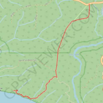
- Distance: 3.6 mi
- Elevation gain: 1,115 ft
- Maximum elevation: 643 ft
- Elevation loss: 1,115 ft
- Minimum elevation: 23 ft
Interactive trail map
Trail profile
- Distance: 3.6 mi
- Elevation gain: 1,115 ft
- Maximum elevation: 643 ft
- Elevation loss: 1,115 ft
- Minimum elevation: 23 ft
About this trail
Name: Sea Lion Caves trail, distance, elevation, map, profile, GPS track
Coordinates: 48.48341 -124.28849 48.49860 -124.27029
Other hiking, mountain biking, running and outdoor activity trails
Click on a trail to view its statistics, map and profile.
BBF loop to the Skydeck in Nanaimo
Canada > British Columbia > Cowichan Valley Regional District > Area A (Mill Bay / Malahat) > Mill Bay
BBF loop to the Skydeck
Distance: 201.0 mi • Elevation gain: 20,413 ft • Maximum elevation: 2,316 ft