Thank you for supporting this site ❤️
Make a donation
Make a donation
Gear up for your next adventure:
As an Amazon Associate, this site earns from qualifying purchases at no extra cost to you.
Moro Rock
Interactive trail map
Thank you for supporting this site ❤️
Make a donation
Make a donation
Gear up for your next adventure:
As an Amazon Associate, this site earns from qualifying purchases at no extra cost to you.
Trail profile
- Distance: 0.5 mi
- Elevation gain: 295 ft
- Maximum elevation: 6,683 ft
- Elevation loss: 302 ft
- Minimum elevation: 6,414 ft
Thank you for supporting this site ❤️
Make a donation
Make a donation
Gear up for your next adventure:
As an Amazon Associate, this site earns from qualifying purchases at no extra cost to you.
About this trail
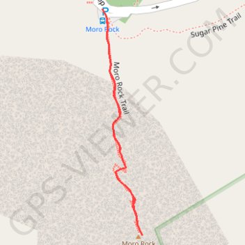
Name: Moro Rock trail, distance, elevation, map, profile, GPS track
Start: Moro Rock Parking, Moro Rock Loop, Tulare County, California, United States (36.54699 -118.76568)
End: Moro Rock Parking, Moro Rock Loop, Tulare County, California, United States (36.54695 -118.76565)
Coordinates: 36.54410 -118.76568 36.54699 -118.76505
Topography: Tulare County topographic map, elevation, terrain
Thank you for supporting this site ❤️
Make a donation
Make a donation
Gear up for your next adventure:
As an Amazon Associate, this site earns from qualifying purchases at no extra cost to you.