Thank you for supporting this site ❤️
Make a donation
Make a donation
Gear up for your next adventure:
As an Amazon Associate, this site earns from qualifying purchases at no extra cost to you.
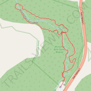
White Pine Bush Scenic Reserve Loop Track
- Distance: 1.2 mi
- Elevation gain: 138 ft
- Maximum elevation: 869 ft
- Elevation loss: 148 ft
- Minimum elevation: 719 ft
- Moving time: 45 m 14 s
- Moving speed: 1.5 mph
- Maximum speed: 2.8 mph
- Total time: 1 h 7 m
- Global speed: 1.0 mph
Interactive trail map
Thank you for supporting this site ❤️
Make a donation
Make a donation
Gear up for your next adventure:
As an Amazon Associate, this site earns from qualifying purchases at no extra cost to you.
Trail profile
- Distance: 1.2 mi
- Elevation gain: 138 ft
- Maximum elevation: 869 ft
- Elevation loss: 148 ft
- Minimum elevation: 719 ft
- Moving time: 45 m 14 s
- Moving speed: 1.5 mph
- Maximum speed: 2.8 mph
- Total time: 1 h 7 m
- Global speed: 1.0 mph
Thank you for supporting this site ❤️
Make a donation
Make a donation
Gear up for your next adventure:
As an Amazon Associate, this site earns from qualifying purchases at no extra cost to you.
About this trail
Name: White Pine Bush Scenic Reserve Loop Track trail, distance, elevation, map, profile, GPS track
Start: White Pine Bush track (paved), Hastings District, Hawke's Bay, New Zealand (-39.28934 176.87964)
End: White Pine Bush track (paved), Hastings District, Hawke's Bay, New Zealand (-39.28964 176.87947)
Coordinates: -39.28968 176.87623 -39.28494 176.88065
Thank you for supporting this site ❤️
Make a donation
Make a donation
Gear up for your next adventure:
As an Amazon Associate, this site earns from qualifying purchases at no extra cost to you.