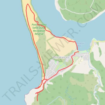
Port Waikato Sand Dune and View Point loop hike
- Distance: 6.7 mi
- Elevation gain: 748 ft
- Maximum elevation: 463 ft
- Elevation loss: 738 ft
- Minimum elevation: 0 ft
- Moving time: 2 h 48 m
- Moving speed: 2.4 mph
- Maximum speed: 10.0 mph
- Total time: 3 h 20 m
- Global speed: 2.0 mph
Interactive trail map
Trail profile
- Distance: 6.7 mi
- Elevation gain: 748 ft
- Maximum elevation: 463 ft
- Elevation loss: 738 ft
- Minimum elevation: 0 ft
- Moving time: 2 h 48 m
- Moving speed: 2.4 mph
- Maximum speed: 10.0 mph
- Total time: 3 h 20 m
- Global speed: 2.0 mph
About this trail
Name: Port Waikato Sand Dune and View Point loop hike trail, distance, elevation, map, profile, GPS track
Start: 108, Maunsell Road, Port Waikato, Waikato District, Waikato, New Zealand (-37.38895 174.72401)
End: Maunsell Road, Port Waikato, Waikato District, Waikato, New Zealand (-37.38959 174.72454)
Coordinates: -37.40520 174.70348 -37.37433 174.72454