Thank you for supporting this site ❤️
Make a donation
Make a donation
Gear up for your next adventure:
As an Amazon Associate, this site earns from qualifying purchases at no extra cost to you.
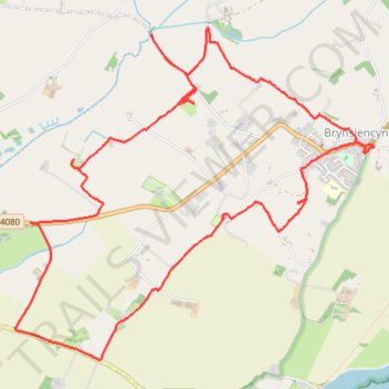
Brynsiencyn loop walk on the Isle of Anglesey
- Distance: 6.3 mi
- Elevation gain: 226 ft
- Maximum elevation: 171 ft
- Elevation loss: 226 ft
- Minimum elevation: 33 ft
- Moving time: 2 h 55 m
- Moving speed: 2.1 mph
- Maximum speed: 3.4 mph
- Total time: 3 h 42 m
- Global speed: 1.7 mph
Interactive trail map
Thank you for supporting this site ❤️
Make a donation
Make a donation
Gear up for your next adventure:
As an Amazon Associate, this site earns from qualifying purchases at no extra cost to you.
Trail profile
- Distance: 6.3 mi
- Elevation gain: 226 ft
- Maximum elevation: 171 ft
- Elevation loss: 226 ft
- Minimum elevation: 33 ft
- Moving time: 2 h 55 m
- Moving speed: 2.1 mph
- Maximum speed: 3.4 mph
- Total time: 3 h 42 m
- Global speed: 1.7 mph
Thank you for supporting this site ❤️
Make a donation
Make a donation
Gear up for your next adventure:
As an Amazon Associate, this site earns from qualifying purchases at no extra cost to you.
About this trail
Name: Brynsiencyn loop walk on the Isle of Anglesey trail, distance, elevation, map, profile, GPS track
End: Llanidan, Brynsiencyn, Isle of Anglesey, Wales, LL61 6TT, United Kingdom (53.17953 -4.26840)
Coordinates: 53.16685 -4.30396 53.18650 -4.26840
Thank you for supporting this site ❤️
Make a donation
Make a donation
Gear up for your next adventure:
As an Amazon Associate, this site earns from qualifying purchases at no extra cost to you.