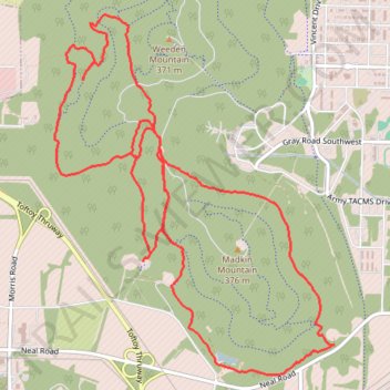
Redstone Arsenal Weeden Mountain and Madkin Mountain trails
RSA
- Distance: 9.4 mi
- Elevation gain: 919 ft
- Maximum elevation: 1,027 ft
- Elevation loss: 919 ft
- Minimum elevation: 630 ft
- Moving time: 1 h 55 m
- Moving speed: 4.9 mph
- Maximum speed: 18.1 mph
- Total time: 2 h 46 m
- Global speed: 3.4 mph
Interactive trail map
Trail profile
- Distance: 9.4 mi
- Elevation gain: 919 ft
- Maximum elevation: 1,027 ft
- Elevation loss: 919 ft
- Minimum elevation: 630 ft
- Moving time: 1 h 55 m
- Moving speed: 4.9 mph
- Maximum speed: 18.1 mph
- Total time: 2 h 46 m
- Global speed: 3.4 mph
About this trail
Name: Redstone Arsenal Weeden Mountain and Madkin Mountain trails trail, distance, elevation, map, profile, GPS track
Start: Madkin Mountain Road, Madison County, Alabama, 35808, United States (34.67472 -86.65151)
End: Madkin Mountain Road, Madison County, Alabama, 35808, United States (34.67476 -86.65152)
Coordinates: 34.65661 -86.66170 34.68567 -86.63426
Topography: Madison County topographic map, elevation, terrain