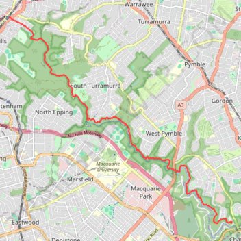
Hike through Lane Cove National Park along the Great North Walk
- Distance: 8.7 mi
- Elevation gain: 1,102 ft
- Maximum elevation: 558 ft
- Elevation loss: 584 ft
- Minimum elevation: 36 ft
- Moving time: 3 h 2 m
- Moving speed: 2.8 mph
- Maximum speed: 11.8 mph
- Total time: 3 h 36 m
- Global speed: 2.4 mph
Interactive trail map
Trail profile
- Distance: 8.7 mi
- Elevation gain: 1,102 ft
- Maximum elevation: 558 ft
- Elevation loss: 584 ft
- Minimum elevation: 36 ft
- Moving time: 3 h 2 m
- Moving speed: 2.8 mph
- Maximum speed: 11.8 mph
- Total time: 3 h 36 m
- Global speed: 2.4 mph
About this trail
Name: Hike through Lane Cove National Park along the Great North Walk trail, distance, elevation, map, profile, GPS track
Coordinates: -33.79046 151.07881 -33.73168 151.15514
Other hiking, mountain biking, running and outdoor activity trails
Click on a trail to view its statistics, map and profile.
Turramurra - Macquarie University
Australia > New South Wales > Sydney
Distance: 4.8 mi • Elevation gain: 341 ft • Maximum elevation: 564 ft