Thank you for supporting this site ❤️
Make a donation
Make a donation
Gear up for your next adventure:
As an Amazon Associate, this site earns from qualifying purchases at no extra cost to you.
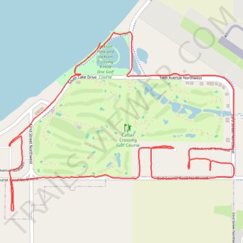
Cattail Crossing Golf Course loop
- Distance: 5.0 mi
- Elevation gain: 75 ft
- Maximum elevation: 1,765 ft
- Elevation loss: 79 ft
- Minimum elevation: 1,716 ft
- Moving time: 34 m 22 s
- Moving speed: 8.8 mph
- Maximum speed: 12.8 mph
- Total time: 36 m 25 s
- Global speed: 8.3 mph
Interactive trail map
Thank you for supporting this site ❤️
Make a donation
Make a donation
Gear up for your next adventure:
As an Amazon Associate, this site earns from qualifying purchases at no extra cost to you.
Trail profile
- Distance: 5.0 mi
- Elevation gain: 75 ft
- Maximum elevation: 1,765 ft
- Elevation loss: 79 ft
- Minimum elevation: 1,716 ft
- Moving time: 34 m 22 s
- Moving speed: 8.8 mph
- Maximum speed: 12.8 mph
- Total time: 36 m 25 s
- Global speed: 8.3 mph
Thank you for supporting this site ❤️
Make a donation
Make a donation
Gear up for your next adventure:
As an Amazon Associate, this site earns from qualifying purchases at no extra cost to you.
About this trail
Name: Cattail Crossing Golf Course loop trail, distance, elevation, map, profile, GPS track
Coordinates: 44.90989 -97.19055 44.92268 -97.16784
Topography: Watertown topographic map, elevation, terrain
Thank you for supporting this site ❤️
Make a donation
Make a donation
Gear up for your next adventure:
As an Amazon Associate, this site earns from qualifying purchases at no extra cost to you.