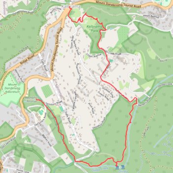
Mechanics Walk, Cascade Track, Olinda Creek Falls, Kalorama Park
- Distance: 3.2 mi
- Elevation gain: 692 ft
- Maximum elevation: 1,667 ft
- Elevation loss: 833 ft
- Minimum elevation: 928 ft
- Moving time: 1 h 33 m
- Moving speed: 2.1 mph
- Maximum speed: 5.7 mph
- Total time: 2 h 34 m
- Global speed: 1.3 mph
Interactive trail map
Trail profile
- Distance: 3.2 mi
- Elevation gain: 692 ft
- Maximum elevation: 1,667 ft
- Elevation loss: 833 ft
- Minimum elevation: 928 ft
- Moving time: 1 h 33 m
- Moving speed: 2.1 mph
- Maximum speed: 5.7 mph
- Total time: 2 h 34 m
- Global speed: 1.3 mph
About this trail
Name: Mechanics Walk, Cascade Track, Olinda Creek Falls, Kalorama Park trail, distance, elevation, map, profile, GPS track
Coordinates: -37.83578 145.36181 -37.81788 145.37606
Other hiking, mountain biking, running and outdoor activity trails
Click on a trail to view its statistics, map and profile.
Dandenong Ranges National Park Ridgewalk
Australia > Victoria > Melbourne > Tremont
Distance: 13.7 mi • Elevation gain: 3,287 ft • Maximum elevation: 1,939 ft