Thank you for supporting this site ❤️
Make a donation
Make a donation
Gear up for your next adventure:
As an Amazon Associate, this site earns from qualifying purchases at no extra cost to you.
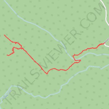
Beaverdam via Joachim's Trail
- Distance: 2.9 mi
- Elevation gain: 673 ft
- Maximum elevation: 4,078 ft
- Elevation loss: 676 ft
- Minimum elevation: 3,570 ft
- Moving time: 1 h 25 m
- Moving speed: 2.0 mph
- Maximum speed: 4.7 mph
- Total time: 1 h 45 m
- Global speed: 1.6 mph
Interactive trail map
Thank you for supporting this site ❤️
Make a donation
Make a donation
Gear up for your next adventure:
As an Amazon Associate, this site earns from qualifying purchases at no extra cost to you.
Trail profile
- Distance: 2.9 mi
- Elevation gain: 673 ft
- Maximum elevation: 4,078 ft
- Elevation loss: 676 ft
- Minimum elevation: 3,570 ft
- Moving time: 1 h 25 m
- Moving speed: 2.0 mph
- Maximum speed: 4.7 mph
- Total time: 1 h 45 m
- Global speed: 1.6 mph
Thank you for supporting this site ❤️
Make a donation
Make a donation
Gear up for your next adventure:
As an Amazon Associate, this site earns from qualifying purchases at no extra cost to you.
About this trail
Name: Beaverdam via Joachim's Trail trail, distance, elevation, map, profile, GPS track
Start: Beaverdam Road, Municipal District of Greenview, Alberta, Canada (53.92458 -119.19202)
End: Beaverdam Road, Municipal District of Greenview, Alberta, Canada (53.92468 -119.19175)
Coordinates: 53.92101 -119.21192 53.92561 -119.19175
Thank you for supporting this site ❤️
Make a donation
Make a donation
Gear up for your next adventure:
As an Amazon Associate, this site earns from qualifying purchases at no extra cost to you.