Thank you for supporting this site ❤️
Make a donation
Make a donation
Gear up for your next adventure:
As an Amazon Associate, this site earns from qualifying purchases at no extra cost to you.
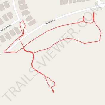
Via Princessa hills
- Distance: 0.8 mi
- Elevation gain: 141 ft
- Maximum elevation: 1,621 ft
- Elevation loss: 141 ft
- Minimum elevation: 1,503 ft
- Moving time: 23 m 31 s
- Moving speed: 2.1 mph
- Maximum speed: 4.0 mph
- Total time: 26 m 40 s
- Global speed: 1.8 mph
Interactive trail map
Thank you for supporting this site ❤️
Make a donation
Make a donation
Gear up for your next adventure:
As an Amazon Associate, this site earns from qualifying purchases at no extra cost to you.
Trail profile
- Distance: 0.8 mi
- Elevation gain: 141 ft
- Maximum elevation: 1,621 ft
- Elevation loss: 141 ft
- Minimum elevation: 1,503 ft
- Moving time: 23 m 31 s
- Moving speed: 2.1 mph
- Maximum speed: 4.0 mph
- Total time: 26 m 40 s
- Global speed: 1.8 mph
Thank you for supporting this site ❤️
Make a donation
Make a donation
Gear up for your next adventure:
As an Amazon Associate, this site earns from qualifying purchases at no extra cost to you.
About this trail
Name: Via Princessa hills trail, distance, elevation, map, profile, GPS track
Coordinates: 34.40796 -118.49110 34.41013 -118.48792
Topography: Santa Clarita topographic map, elevation, terrain
Thank you for supporting this site ❤️
Make a donation
Make a donation
Gear up for your next adventure:
As an Amazon Associate, this site earns from qualifying purchases at no extra cost to you.