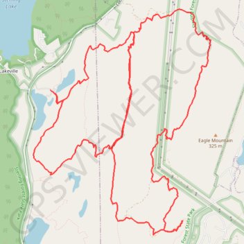
Sterling Mountain Bike Ride
- Distance: 13.2 mi
- Elevation gain: 1,673 ft
- Maximum elevation: 1,096 ft
- Elevation loss: 1,673 ft
- Minimum elevation: 587 ft
- Moving time: 2 h 22 m
- Moving speed: 5.5 mph
- Maximum speed: 21.1 mph
- Total time: 2 h 23 m
- Global speed: 5.5 mph
Interactive trail map
Trail profile
- Distance: 13.2 mi
- Elevation gain: 1,673 ft
- Maximum elevation: 1,096 ft
- Elevation loss: 1,673 ft
- Minimum elevation: 587 ft
- Moving time: 2 h 22 m
- Moving speed: 5.5 mph
- Maximum speed: 21.1 mph
- Total time: 2 h 23 m
- Global speed: 5.5 mph
About this trail
Name: Sterling Mountain Bike Ride trail, distance, elevation, map, profile, GPS track
Coordinates: 41.17457 -74.25586 41.20584 -74.22323
Topography: Orange County topographic map, elevation, terrain
Other hiking, mountain biking, running and outdoor activity trails
Click on a trail to view its statistics, map and profile.
Sterling Forest State Park
United States > New York > Orange County > Town of Warwick > Lakeville
Mountain Bike Ride
Distance: 12.6 mi • Elevation gain: 1,535 ft • Maximum elevation: 1,096 ft