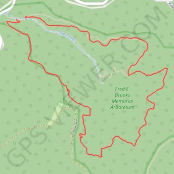
Honeybee Trail - Watoga State Park
- Distance: 4.3 mi
- Elevation gain: 892 ft
- Maximum elevation: 2,992 ft
- Elevation loss: 899 ft
- Minimum elevation: 2,434 ft
- Moving time: 13 m 5 s
- Moving speed: 19.9 mph
- Maximum speed: 27.9 mph
- Total time: 13 m 5 s
- Global speed: 19.9 mph
Interactive trail map
Trail profile
- Distance: 4.3 mi
- Elevation gain: 892 ft
- Maximum elevation: 2,992 ft
- Elevation loss: 899 ft
- Minimum elevation: 2,434 ft
- Moving time: 13 m 5 s
- Moving speed: 19.9 mph
- Maximum speed: 27.9 mph
- Total time: 13 m 5 s
- Global speed: 19.9 mph
About this trail
Name: Honeybee Trail - Watoga State Park trail, distance, elevation, map, profile, GPS track
Start: Honey Bee Trail, Pocahontas County, West Virginia, United States (38.11938 -80.15425)
End: Honey Bee Trail, Pocahontas County, West Virginia, United States (38.11922 -80.15549)
Coordinates: 38.10542 -80.15675 38.11945 -80.13631
Topography: Pocahontas County topographic map, elevation, terrain