Mount Amos
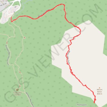
Interactive trail map
Trail profile
- Distance: 2.7 mi
- Elevation gain: 1,352 ft
- Maximum elevation: 1,467 ft
- Elevation loss: 1,345 ft
- Minimum elevation: 141 ft
- Moving time: 1 h 17 m
- Moving speed: 2.1 mph
- Maximum speed: 4.9 mph
- Total time: 2 h 18 m
- Global speed: 1.2 mph
About this trail
Name: Mount Amos trail, distance, elevation, map, profile, GPS track
Coordinates: -42.15388 148.28917 -42.14488 148.29957
Other hiking, mountain biking, running and outdoor activity trails
Click on a trail to view its statistics, map and profile.
Mount Mayson Loop - Hazards Beach - Wineglass Bay Lookout - Coles Bay Lookout
Distance: 7.2 mi • Elevation gain: 1,093 ft • Maximum elevation: 673 ft
Peninsula Track - Mount Freycinet
Distance: 18.9 mi • Elevation gain: 3,986 ft • Maximum elevation: 1,965 ft