Thank you for supporting this site ❤️
Make a donation
Make a donation
Gear up for your next adventure:
As an Amazon Associate, this site earns from qualifying purchases at no extra cost to you.
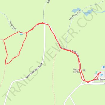
Short walk at Wells State Park
- Distance: 0.9 mi
- Elevation gain: 121 ft
- Maximum elevation: 728 ft
- Elevation loss: 125 ft
- Minimum elevation: 604 ft
- Moving time: 23 m 46 s
- Moving speed: 2.3 mph
- Maximum speed: 4.0 mph
- Total time: 24 m 20 s
- Global speed: 2.3 mph
Interactive trail map
Thank you for supporting this site ❤️
Make a donation
Make a donation
Gear up for your next adventure:
As an Amazon Associate, this site earns from qualifying purchases at no extra cost to you.
Trail profile
- Distance: 0.9 mi
- Elevation gain: 121 ft
- Maximum elevation: 728 ft
- Elevation loss: 125 ft
- Minimum elevation: 604 ft
- Moving time: 23 m 46 s
- Moving speed: 2.3 mph
- Maximum speed: 4.0 mph
- Total time: 24 m 20 s
- Global speed: 2.3 mph
Thank you for supporting this site ❤️
Make a donation
Make a donation
Gear up for your next adventure:
As an Amazon Associate, this site earns from qualifying purchases at no extra cost to you.
About this trail
Name: Short walk at Wells State Park trail, distance, elevation, map, profile, GPS track
Coordinates: 42.14646 -72.06623 42.14890 -72.06088
Topography: Worcester County topographic map, elevation, terrain
Thank you for supporting this site ❤️
Make a donation
Make a donation
Gear up for your next adventure:
As an Amazon Associate, this site earns from qualifying purchases at no extra cost to you.