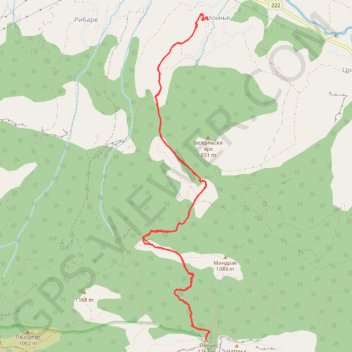
Beloinje-Pleš
- Distance: 8.4 mi
- Elevation gain: 2,831 ft
- Maximum elevation: 4,124 ft
- Elevation loss: 2,831 ft
- Minimum elevation: 1,368 ft
- Moving time: 5 h 10 m
- Moving speed: 1.6 mph
- Maximum speed: 4.7 mph
- Total time: 8 h 56 m
- Global speed: 0.9 mph
Interactive trail map
Trail profile
- Distance: 8.4 mi
- Elevation gain: 2,831 ft
- Maximum elevation: 4,124 ft
- Elevation loss: 2,831 ft
- Minimum elevation: 1,368 ft
- Moving time: 5 h 10 m
- Moving speed: 1.6 mph
- Maximum speed: 4.7 mph
- Total time: 8 h 56 m
- Global speed: 0.9 mph
About this trail
Name: Beloinje-Pleš trail, distance, elevation, map, profile, GPS track
Coordinates: 43.35404 22.15448 43.39314 22.16544