Thank you for supporting this site ❤️
Make a donation
Make a donation
Gear up for your next adventure:
As an Amazon Associate, this site earns from qualifying purchases at no extra cost to you.
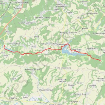
TRK000
- Distance: 21.8 mi
- Elevation gain: 725 ft
- Maximum elevation: 364 ft
- Elevation loss: 725 ft
- Minimum elevation: 203 ft
Interactive trail map
Thank you for supporting this site ❤️
Make a donation
Make a donation
Gear up for your next adventure:
As an Amazon Associate, this site earns from qualifying purchases at no extra cost to you.
Trail profile
- Distance: 21.8 mi
- Elevation gain: 725 ft
- Maximum elevation: 364 ft
- Elevation loss: 725 ft
- Minimum elevation: 203 ft
Thank you for supporting this site ❤️
Make a donation
Make a donation
Gear up for your next adventure:
As an Amazon Associate, this site earns from qualifying purchases at no extra cost to you.
About this trail
Name: TRK000 trail, distance, elevation, map, profile, GPS track
Coordinates: 49.45225 3.55199 49.47448 3.74369
Thank you for supporting this site ❤️
Make a donation
Make a donation
Gear up for your next adventure:
As an Amazon Associate, this site earns from qualifying purchases at no extra cost to you.