Thank you for supporting this site ❤️
Make a donation
Make a donation
Gear up for your next adventure:
As an Amazon Associate, this site earns from qualifying purchases at no extra cost to you.
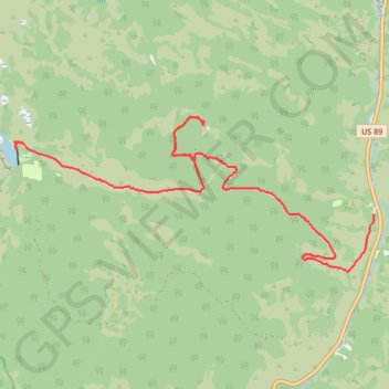
Tony Grove Lake
- Distance: 9.1 mi
- Elevation gain: 2,218 ft
- Maximum elevation: 8,061 ft
- Elevation loss: 417 ft
- Minimum elevation: 6,247 ft
- Moving time: 1 h 21 m
- Moving speed: 6.7 mph
- Maximum speed: 27.6 mph
- Total time: 1 h 29 m
- Global speed: 6.1 mph
Interactive trail map
Thank you for supporting this site ❤️
Make a donation
Make a donation
Gear up for your next adventure:
As an Amazon Associate, this site earns from qualifying purchases at no extra cost to you.
Trail profile
- Distance: 9.1 mi
- Elevation gain: 2,218 ft
- Maximum elevation: 8,061 ft
- Elevation loss: 417 ft
- Minimum elevation: 6,247 ft
- Moving time: 1 h 21 m
- Moving speed: 6.7 mph
- Maximum speed: 27.6 mph
- Total time: 1 h 29 m
- Global speed: 6.1 mph
Thank you for supporting this site ❤️
Make a donation
Make a donation
Gear up for your next adventure:
As an Amazon Associate, this site earns from qualifying purchases at no extra cost to you.
About this trail
Name: Tony Grove Lake trail, distance, elevation, map, profile, GPS track
Start: Tony Grove Road, Cache County, Utah, United States (41.88336 -111.56428)
End: Tony Grove Road, Cache County, Utah, United States (41.89496 -111.64123)
Coordinates: 41.87402 -111.64251 41.89908 -111.56428
Topography: Cache County topographic map, elevation, terrain
Thank you for supporting this site ❤️
Make a donation
Make a donation
Gear up for your next adventure:
As an Amazon Associate, this site earns from qualifying purchases at no extra cost to you.