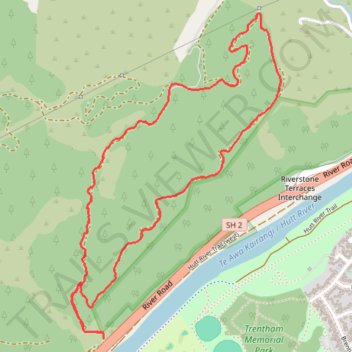
Moonshine Forest Loop Walk
- Distance: 3.1 mi
- Elevation gain: 758 ft
- Maximum elevation: 679 ft
- Elevation loss: 725 ft
- Minimum elevation: 148 ft
- Moving time: 56 m 31 s
- Moving speed: 3.3 mph
- Maximum speed: 10.0 mph
- Total time: 57 m 55 s
- Global speed: 3.2 mph
Interactive trail map
Trail profile
- Distance: 3.1 mi
- Elevation gain: 758 ft
- Maximum elevation: 679 ft
- Elevation loss: 725 ft
- Minimum elevation: 148 ft
- Moving time: 56 m 31 s
- Moving speed: 3.3 mph
- Maximum speed: 10.0 mph
- Total time: 57 m 55 s
- Global speed: 3.2 mph
About this trail
Name: Moonshine Forest Loop Walk trail, distance, elevation, map, profile, GPS track
Coordinates: -41.13151 175.01799 -41.11772 175.02975