Thank you for supporting this site ❤️
Make a donation
Make a donation
Gear up for your next adventure:
As an Amazon Associate, this site earns from qualifying purchases at no extra cost to you.
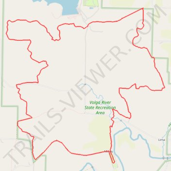
Volga River State Recreation Area Loop Hike
- Distance: 12.1 mi
- Elevation gain: 1,030 ft
- Maximum elevation: 1,175 ft
- Elevation loss: 1,030 ft
- Minimum elevation: 925 ft
- Moving time: 2 h 46 m
- Moving speed: 4.4 mph
- Maximum speed: 10.4 mph
- Total time: 3 h 17 m
- Global speed: 3.7 mph
Interactive trail map
Thank you for supporting this site ❤️
Make a donation
Make a donation
Gear up for your next adventure:
As an Amazon Associate, this site earns from qualifying purchases at no extra cost to you.
Trail profile
- Distance: 12.1 mi
- Elevation gain: 1,030 ft
- Maximum elevation: 1,175 ft
- Elevation loss: 1,030 ft
- Minimum elevation: 925 ft
- Moving time: 2 h 46 m
- Moving speed: 4.4 mph
- Maximum speed: 10.4 mph
- Total time: 3 h 17 m
- Global speed: 3.7 mph
Thank you for supporting this site ❤️
Make a donation
Make a donation
Gear up for your next adventure:
As an Amazon Associate, this site earns from qualifying purchases at no extra cost to you.
About this trail
Name: Volga River State Recreation Area Loop Hike trail, distance, elevation, map, profile, GPS track
Start: Hill Road, Albany, Fayette County, Iowa, United States (42.87100 -91.75774)
End: Hill Road, Albany, Fayette County, Iowa, 52142, United States (42.87121 -91.75781)
Coordinates: 42.86316 -91.78905 42.89698 -91.74204
Topography: Fayette County topographic map, elevation, terrain
Thank you for supporting this site ❤️
Make a donation
Make a donation
Gear up for your next adventure:
As an Amazon Associate, this site earns from qualifying purchases at no extra cost to you.