Make a donation
Gear up for your next adventure:
As an Amazon Associate, this site earns from qualifying purchases at no extra cost to you.
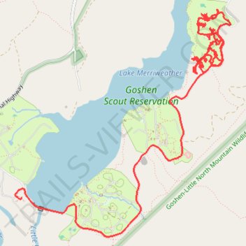
Tracked with OSMTracker for Android™
Marriott north
- Distance: 8.1 mi
- Elevation gain: 807 ft
- Maximum elevation: 1,608 ft
- Elevation loss: 787 ft
- Minimum elevation: 1,358 ft
Interactive trail map
Make a donation
Gear up for your next adventure:
As an Amazon Associate, this site earns from qualifying purchases at no extra cost to you.
Trail profile
- Distance: 8.1 mi
- Elevation gain: 807 ft
- Maximum elevation: 1,608 ft
- Elevation loss: 787 ft
- Minimum elevation: 1,358 ft
Make a donation
Gear up for your next adventure:
As an Amazon Associate, this site earns from qualifying purchases at no extra cost to you.
About this trail
Name: Tracked with OSMTracker for Android™ trail, distance, elevation, map, profile, GPS track
Start: Camp Mariott, Beltway Drive, Rockbridge County, Virginia, 24439, United States (37.97727 -79.43637)
End: Beltway Drive, Rockbridge County, Virginia, 24439, United States (37.96067 -79.46183)
Coordinates: 37.95658 -79.46278 37.98081 -79.43359
Topography: Rockbridge County topographic map, elevation, terrain
Make a donation
Gear up for your next adventure:
As an Amazon Associate, this site earns from qualifying purchases at no extra cost to you.
Other hiking, mountain biking, running and outdoor activity trails
Click on a trail to view its statistics, map and profile.
Goshen Pass Hiking via Jump Rock and Viewing Rock
United States > Virginia > Rockbridge County
Distance: 8.2 mi • Elevation gain: 2,388 ft • Maximum elevation: 3,051 ft
Tracked with OSMTracker for Android™
United States > Virginia > Rockbridge County
Marriott south
Distance: 2.0 mi • Elevation gain: 125 ft • Maximum elevation: 1,486 ft