Thank you for supporting this site ❤️
Make a donation
Make a donation
Gear up for your next adventure:
As an Amazon Associate, this site earns from qualifying purchases at no extra cost to you.
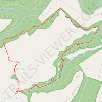
Hotwater Loop via Soddy Creek Gorge Trail (North)
- Distance: 4.9 mi
- Elevation gain: 922 ft
- Maximum elevation: 1,516 ft
- Elevation loss: 925 ft
- Minimum elevation: 1,119 ft
- Moving time: 2 h 1 m
- Moving speed: 2.4 mph
- Maximum speed: 4.7 mph
- Total time: 2 h 28 m
- Global speed: 2.0 mph
Interactive trail map
Thank you for supporting this site ❤️
Make a donation
Make a donation
Gear up for your next adventure:
As an Amazon Associate, this site earns from qualifying purchases at no extra cost to you.
Trail profile
- Distance: 4.9 mi
- Elevation gain: 922 ft
- Maximum elevation: 1,516 ft
- Elevation loss: 925 ft
- Minimum elevation: 1,119 ft
- Moving time: 2 h 1 m
- Moving speed: 2.4 mph
- Maximum speed: 4.7 mph
- Total time: 2 h 28 m
- Global speed: 2.0 mph
Thank you for supporting this site ❤️
Make a donation
Make a donation
Gear up for your next adventure:
As an Amazon Associate, this site earns from qualifying purchases at no extra cost to you.
About this trail
Name: Hotwater Loop via Soddy Creek Gorge Trail (North) trail, distance, elevation, map, profile, GPS track
Start: Sluder Lane, Hamilton County, East Tennessee, Tennessee, 37379, United States (35.28152 -85.19382)
Coordinates: 35.28126 -85.19711 35.29926 -85.17246
Topography: Hamilton County topographic map, elevation, terrain
Thank you for supporting this site ❤️
Make a donation
Make a donation
Gear up for your next adventure:
As an Amazon Associate, this site earns from qualifying purchases at no extra cost to you.