Thank you for supporting this site ❤️
Make a donation
Make a donation
Gear up for your next adventure:
As an Amazon Associate, this site earns from qualifying purchases at no extra cost to you.
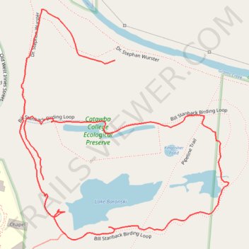
Bill Stanback Birding Loop in Catawba College Ecological Preserve
- Distance: 1.3 mi
- Elevation gain: 108 ft
- Maximum elevation: 676 ft
- Elevation loss: 79 ft
- Minimum elevation: 623 ft
- Moving time: 37 m 1 s
- Moving speed: 2.2 mph
- Maximum speed: 7.5 mph
- Total time: 1 h 1 m
- Global speed: 1.3 mph
Interactive trail map
Thank you for supporting this site ❤️
Make a donation
Make a donation
Gear up for your next adventure:
As an Amazon Associate, this site earns from qualifying purchases at no extra cost to you.
Trail profile
- Distance: 1.3 mi
- Elevation gain: 108 ft
- Maximum elevation: 676 ft
- Elevation loss: 79 ft
- Minimum elevation: 623 ft
- Moving time: 37 m 1 s
- Moving speed: 2.2 mph
- Maximum speed: 7.5 mph
- Total time: 1 h 1 m
- Global speed: 1.3 mph
Thank you for supporting this site ❤️
Make a donation
Make a donation
Gear up for your next adventure:
As an Amazon Associate, this site earns from qualifying purchases at no extra cost to you.
About this trail
Name: Bill Stanback Birding Loop in Catawba College Ecological Preserve trail, distance, elevation, map, profile, GPS track
Coordinates: 35.69066 -80.48027 35.69528 -80.47511
Topography: Salisbury topographic map, elevation, terrain
Thank you for supporting this site ❤️
Make a donation
Make a donation
Gear up for your next adventure:
As an Amazon Associate, this site earns from qualifying purchases at no extra cost to you.