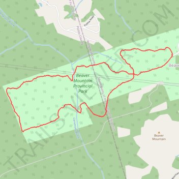
Beaver Mountain Provincial Park Loop Trail
- Distance: 3.6 mi
- Elevation gain: 417 ft
- Maximum elevation: 781 ft
- Elevation loss: 417 ft
- Minimum elevation: 548 ft
- Moving time: 1 h 34 m
- Moving speed: 2.3 mph
- Maximum speed: 5.3 mph
- Total time: 1 h 36 m
- Global speed: 2.3 mph
Interactive trail map
Trail profile
- Distance: 3.6 mi
- Elevation gain: 417 ft
- Maximum elevation: 781 ft
- Elevation loss: 417 ft
- Minimum elevation: 548 ft
- Moving time: 1 h 34 m
- Moving speed: 2.3 mph
- Maximum speed: 5.3 mph
- Total time: 1 h 36 m
- Global speed: 2.3 mph
About this trail
Name: Beaver Mountain Provincial Park Loop Trail trail, distance, elevation, map, profile, GPS track
Coordinates: 45.55800 -62.18045 45.56661 -62.15634
Other hiking, mountain biking, running and outdoor activity trails
Click on a trail to view its statistics, map and profile.
Pictou - Antigonish
Canada > Nova Scotia > Town of Pictou > Pictou
#Bike #Pictou #Antigonish
Distance: 46.2 mi • Elevation gain: 2,441 ft • Maximum elevation: 505 ft