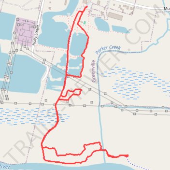
Hike at River Park North, Parker's Creek, Old Eason, and Willow Branch Trails
- Distance: 3.0 mi
- Elevation gain: 23 ft
- Maximum elevation: 26 ft
- Elevation loss: 23 ft
- Minimum elevation: 7 ft
- Moving time: 1 h 56 s
- Moving speed: 3.0 mph
- Maximum speed: 4.6 mph
- Total time: 1 h 3 m
- Global speed: 2.9 mph
Interactive trail map
Trail profile
- Distance: 3.0 mi
- Elevation gain: 23 ft
- Maximum elevation: 26 ft
- Elevation loss: 23 ft
- Minimum elevation: 7 ft
- Moving time: 1 h 56 s
- Moving speed: 3.0 mph
- Maximum speed: 4.6 mph
- Total time: 1 h 3 m
- Global speed: 2.9 mph
About this trail
Name: Hike at River Park North, Parker's Creek, Old Eason, and Willow Branch Trails trail, distance, elevation, map, profile, GPS track
Start: Mumford Road, Greenville, Pitt County, North Carolina, 27834, United States (35.62760 -77.35995)
End: Mumford Road, Greenville, Pitt County, North Carolina, 27834, United States (35.62764 -77.35992)
Coordinates: 35.61624 -77.36399 35.62764 -77.35626
Topography: Greenville topographic map, elevation, terrain