Make a donation
Gear up for your next adventure:
As an Amazon Associate, this site earns from qualifying purchases at no extra cost to you.
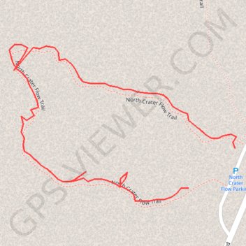
North Crater Flow Trail
Craters of the Moon National Monument
- Distance: 0.4 mi
- Elevation gain: 16 ft
- Maximum elevation: 5,876 ft
- Elevation loss: 13 ft
- Minimum elevation: 5,856 ft
Interactive trail map
Make a donation
Gear up for your next adventure:
As an Amazon Associate, this site earns from qualifying purchases at no extra cost to you.
Trail profile
- Distance: 0.4 mi
- Elevation gain: 16 ft
- Maximum elevation: 5,876 ft
- Elevation loss: 13 ft
- Minimum elevation: 5,856 ft
Make a donation
Gear up for your next adventure:
As an Amazon Associate, this site earns from qualifying purchases at no extra cost to you.
About this trail
Name: North Crater Flow Trail trail, distance, elevation, map, profile, GPS track
Start: North Crater Flow Trail, Butte County, Idaho, United States (43.45738 -113.55918)
End: North Crater Flow Trail, Butte County, Idaho, United States (43.45769 -113.55868)
Coordinates: 43.45728 -113.56111 43.45850 -113.55866
Topography: Butte County topographic map, elevation, terrain
Make a donation
Gear up for your next adventure:
As an Amazon Associate, this site earns from qualifying purchases at no extra cost to you.