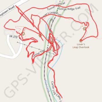
Natural Tunnel
- Distance: 2.1 mi
- Elevation gain: 883 ft
- Maximum elevation: 1,709 ft
- Elevation loss: 883 ft
- Minimum elevation: 1,342 ft
- Moving time: 1 h 2 m
- Moving speed: 2.0 mph
- Maximum speed: 13.7 mph
- Total time: 1 h 28 m
- Global speed: 1.4 mph
Interactive trail map
Trail profile
- Distance: 2.1 mi
- Elevation gain: 883 ft
- Maximum elevation: 1,709 ft
- Elevation loss: 883 ft
- Minimum elevation: 1,342 ft
- Moving time: 1 h 2 m
- Moving speed: 2.0 mph
- Maximum speed: 13.7 mph
- Total time: 1 h 28 m
- Global speed: 1.4 mph
About this trail
Name: Natural Tunnel trail, distance, elevation, map, profile, GPS track
Start: Lover's Leap Trail, Scott County, Virginia, 24244, United States (36.70227 -82.74594)
End: Lover's Leap Trail, Scott County, Virginia, 24244, United States (36.70232 -82.74600)
Coordinates: 36.69993 -82.74648 36.70323 -82.74239
Topography: Scott County topographic map, elevation, terrain