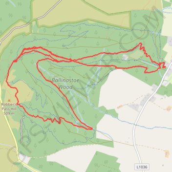
Ballinastoe Wood Loop MTB
- Distance: 7.2 mi
- Elevation gain: 1,102 ft
- Maximum elevation: 1,647 ft
- Elevation loss: 1,132 ft
- Minimum elevation: 1,053 ft
- Moving time: 1 h 16 m
- Moving speed: 5.7 mph
- Maximum speed: 24.6 mph
- Total time: 2 h 3 m
- Global speed: 3.5 mph
Interactive trail map
Trail profile
- Distance: 7.2 mi
- Elevation gain: 1,102 ft
- Maximum elevation: 1,647 ft
- Elevation loss: 1,132 ft
- Minimum elevation: 1,053 ft
- Moving time: 1 h 16 m
- Moving speed: 5.7 mph
- Maximum speed: 24.6 mph
- Total time: 2 h 3 m
- Global speed: 3.5 mph
About this trail
Name: Ballinastoe Wood Loop MTB trail, distance, elevation, map, profile, GPS track
Coordinates: 53.09939 -6.25349 53.11119 -6.21726
Other hiking, mountain biking, running and outdoor activity trails
Click on a trail to view its statistics, map and profile.
Ballinastoe Wood Loop MTB
Distance: 7.1 mi • Elevation gain: 1,066 ft • Maximum elevation: 1,585 ft
Ballinastoe Wood MTB Loop
Distance: 9.1 mi • Elevation gain: 1,680 ft • Maximum elevation: 1,821 ft
Ballinastoe MTB
Distance: 8.1 mi • Elevation gain: 1,234 ft • Maximum elevation: 1,647 ft
White Hill Hike
Distance: 2.8 mi • Elevation gain: 525 ft • Maximum elevation: 2,060 ft