Chimney Tops
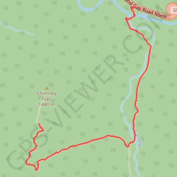
Interactive trail map
Trail profile
- Distance: 3.7 mi
- Elevation gain: 1,519 ft
- Maximum elevation: 4,708 ft
- Elevation loss: 1,516 ft
- Minimum elevation: 3,448 ft
About this trail
Name: Chimney Tops trail, distance, elevation, map, profile, GPS track
Coordinates: 35.62337 -83.47961 35.63548 -83.46825
Topography: Sevier County topographic map, elevation, terrain
Other hiking, mountain biking, running and outdoor activity trails
Click on a trail to view its statistics, map and profile.
Chimney Tops Trail in Great Smoky Mountains National Park
United States > Tennessee > Sevier County > Fort Harry
The Chimney Tops Trail in Great Smoky Mountains National Park offers a thrilling and challenging hike with some of the most breathtaking panoramic views in the region. As you ascend, you'll pass through dense forests of towering trees and cross streams over rustic bridges, eventually reaching a dramatic rocky…
Distance: 4.0 mi • Elevation gain: 1,568 ft • Maximum elevation: 4,708 ft
Chimney Tops Trail in Great Smoky Mountains National Park
United States > Tennessee > Sevier County > Fort Harry
The Chimney Tops Trail is a well-loved hiking route known for its stunning mountain vistas and diverse natural beauty. This trail features a steep ascent, crossing several picturesque streams and providing breathtaking views, particularly of Mount LeConte and Sugarland Mountain, along its path. This trail is a…
Distance: 4.0 mi • Elevation gain: 1,581 ft • Maximum elevation: 4,708 ft
Great Smoky Mountains Appalachian Trail
United States > North Carolina > Clay County
Hike through Great Smoky Mountains along Appalachian Trail via Standing Indian, Ridgepole Mountain, Yellow Bald, Wine Spring Bald, Copper Ridge Bald, Cheoah Bald, Wauchecha Bald, Fontana Dam, Thunderhead Mountain, Clingmans Dome, Mount Kephart and Mount Guyot. #Hiking #Mountain #Nature #Forest #Lake…
Distance: 144.0 mi • Elevation gain: 29,111 ft • Maximum elevation: 6,604 ft