Thank you for supporting this site ❤️
Make a donation
Make a donation
Gear up for your next adventure:
As an Amazon Associate, this site earns from qualifying purchases at no extra cost to you.
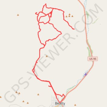
Beatty
- Distance: 39.9 mi
- Elevation gain: 5,102 ft
- Maximum elevation: 4,452 ft
- Elevation loss: 4,236 ft
- Minimum elevation: 3,310 ft
- Moving time: 3 h 36 m
- Moving speed: 11.1 mph
- Maximum speed: 42.1 mph
- Total time: 5 h 59 m
- Global speed: 6.7 mph
Interactive trail map
Thank you for supporting this site ❤️
Make a donation
Make a donation
Gear up for your next adventure:
As an Amazon Associate, this site earns from qualifying purchases at no extra cost to you.
Trail profile
- Distance: 39.9 mi
- Elevation gain: 5,102 ft
- Maximum elevation: 4,452 ft
- Elevation loss: 4,236 ft
- Minimum elevation: 3,310 ft
- Moving time: 3 h 36 m
- Moving speed: 11.1 mph
- Maximum speed: 42.1 mph
- Total time: 5 h 59 m
- Global speed: 6.7 mph
Thank you for supporting this site ❤️
Make a donation
Make a donation
Gear up for your next adventure:
As an Amazon Associate, this site earns from qualifying purchases at no extra cost to you.
About this trail
Name: Beatty trail, distance, elevation, map, profile, GPS track
Start: 1383, North B Avenue, Beatty, Nye County, Nevada, 89003, United States (36.91348 -116.76377)
End: Beatty, Nye County, Nevada, 89003, United States (36.97474 -116.77437)
Coordinates: 36.90853 -116.79609 37.01423 -116.73971
Topography: Nye County topographic map, elevation, terrain
Thank you for supporting this site ❤️
Make a donation
Make a donation
Gear up for your next adventure:
As an Amazon Associate, this site earns from qualifying purchases at no extra cost to you.