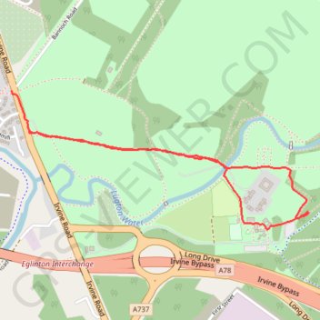
Eglinton Country Park, Scotland
Afternoon Run
- Distance: 1.7 mi
- Elevation gain: 52 ft
- Maximum elevation: 59 ft
- Elevation loss: 52 ft
- Minimum elevation: 26 ft
- Moving time: 29 m 54 s
- Moving speed: 3.5 mph
- Maximum speed: 6.3 mph
- Total time: 33 m 46 s
- Global speed: 3.1 mph
Interactive trail map
Trail profile
- Distance: 1.7 mi
- Elevation gain: 52 ft
- Maximum elevation: 59 ft
- Elevation loss: 52 ft
- Minimum elevation: 26 ft
- Moving time: 29 m 54 s
- Moving speed: 3.5 mph
- Maximum speed: 6.3 mph
- Total time: 33 m 46 s
- Global speed: 3.1 mph
About this trail
Name: Eglinton Country Park, Scotland trail, distance, elevation, map, profile, GPS track
Start: Irvine Road, Kilwinning, North Ayrshire, Scotland, KA13 7PW, United Kingdom (55.64513 -4.68592)
End: Irvine Road, Kilwinning, North Ayrshire, Scotland, KA13 7PW, United Kingdom (55.64656 -4.68695)
Coordinates: 55.64178 -4.68695 55.64656 -4.66891
Other hiking, mountain biking, running and outdoor activity trails
Click on a trail to view its statistics, map and profile.
Irvine, Scotland to Stevenston and back
United Kingdom > Scotland > North Ayrshire > Irvine
Morning Bike Ride
Distance: 11.7 mi • Elevation gain: 226 ft • Maximum elevation: 92 ft
Irvine, Scotland to Largs and back
United Kingdom > Scotland > North Ayrshire > Irvine
Morning Bike Ride
Distance: 41.6 mi • Elevation gain: 1,063 ft • Maximum elevation: 115 ft
Irvine, Scotland to Eglinton Country Park and back
United Kingdom > Scotland > North Ayrshire > Irvine
Loop Bike
Distance: 8.5 mi • Elevation gain: 220 ft • Maximum elevation: 105 ft
Irvine, Scotland to West Kilbride and back
United Kingdom > Scotland > North Ayrshire > Irvine
Afternoon Bike Ride
Distance: 25.0 mi • Elevation gain: 928 ft • Maximum elevation: 331 ft
Irvine, Scotland to Stevenston and back
United Kingdom > Scotland > North Ayrshire > Irvine
Afternoon Bike Ride
Distance: 11.7 mi • Elevation gain: 233 ft • Maximum elevation: 92 ft
Irvine, Scotland to Stevenston and back
United Kingdom > Scotland > North Ayrshire > Irvine
Evening Bike Ride
Distance: 11.6 mi • Elevation gain: 217 ft • Maximum elevation: 72 ft
Irvine, Scotland to Stevenston and back
United Kingdom > Scotland > North Ayrshire > Irvine
Morning Bike Ride
Distance: 11.8 mi • Elevation gain: 246 ft • Maximum elevation: 95 ft
Irvine, Scotland to Saltcoats and back
United Kingdom > Scotland > North Ayrshire > Irvine
Afternoon Bike Ride
Distance: 13.9 mi • Elevation gain: 266 ft • Maximum elevation: 72 ft
Irvine, Scotland to Stevenston and back
United Kingdom > Scotland > North Ayrshire > Irvine
Bike
Distance: 13.3 mi • Elevation gain: 289 ft • Maximum elevation: 92 ft
Irvine, Scotland to Stevenston and back
United Kingdom > Scotland > North Ayrshire > Irvine
Bike
Distance: 11.3 mi • Elevation gain: 220 ft • Maximum elevation: 72 ft
Irvine, Scotland to Stevenston and back
United Kingdom > Scotland > North Ayrshire > Irvine
Bike
Distance: 8.2 mi • Elevation gain: 177 ft • Maximum elevation: 89 ft
Irvine, Scotland to Stevenston and back
United Kingdom > Scotland > North Ayrshire > Irvine
Bike
Distance: 11.5 mi • Elevation gain: 213 ft • Maximum elevation: 92 ft
Irvine, Scotland to Stevenston and back
United Kingdom > Scotland > North Ayrshire > Irvine
Bike
Distance: 10.7 mi • Elevation gain: 161 ft • Maximum elevation: 43 ft
Irvine, Scotland to Ardrossan and back
United Kingdom > Scotland > North Ayrshire > Irvine
Bike
Distance: 19.4 mi • Elevation gain: 377 ft • Maximum elevation: 72 ft
Irvine, Scotland to Dalry and back
United Kingdom > Scotland > North Ayrshire > Irvine
Evening Loop Bike Ride
Distance: 17.9 mi • Elevation gain: 899 ft • Maximum elevation: 348 ft
Irvine, Scotland to Dalry and back
United Kingdom > Scotland > North Ayrshire > Irvine
Evening Bike Ride
Distance: 14.5 mi • Elevation gain: 633 ft • Maximum elevation: 230 ft
Irvine, Scotland to Fairlie and back
United Kingdom > Scotland > North Ayrshire > Irvine
Bike
Distance: 32.2 mi • Elevation gain: 1,703 ft • Maximum elevation: 827 ft
Irvine, Scotland to Dalry and back
United Kingdom > Scotland > North Ayrshire > Irvine
Bike
Distance: 16.6 mi • Elevation gain: 833 ft • Maximum elevation: 230 ft
Irvine, Scotland to Kilwinning
United Kingdom > Scotland > North Ayrshire > Irvine
Afternoon Bike Ride
Distance: 3.3 mi • Elevation gain: 66 ft • Maximum elevation: 72 ft
Irvine, Scotland to Kilwinning
United Kingdom > Scotland > North Ayrshire > Irvine
Afternoon Bike Ride
Distance: 3.3 mi • Elevation gain: 66 ft • Maximum elevation: 72 ft
Irvine, Scotland to Kilwinning
United Kingdom > Scotland > North Ayrshire > Irvine
Afternoon Bike Ride
Distance: 3.7 mi • Elevation gain: 69 ft • Maximum elevation: 72 ft
Kilwinning, Scotland to Irvine
United Kingdom > Scotland > North Ayrshire > Kilwinning
Evening Bike Ride
Distance: 4.7 mi • Elevation gain: 72 ft • Maximum elevation: 75 ft
Irvine, Scotland to Kilwinning
United Kingdom > Scotland > North Ayrshire > Irvine
Morning Bike Ride
Distance: 3.6 mi • Elevation gain: 72 ft • Maximum elevation: 72 ft