Thank you for supporting this site ❤️
Make a donation
Make a donation
Gear up for your next adventure:
As an Amazon Associate, this site earns from qualifying purchases at no extra cost to you.
North Yuba River MTB Loop
Interactive trail map
Thank you for supporting this site ❤️
Make a donation
Make a donation
Gear up for your next adventure:
As an Amazon Associate, this site earns from qualifying purchases at no extra cost to you.
Trail profile
- Distance: 19.9 mi
- Elevation gain: 6,076 ft
- Maximum elevation: 4,111 ft
- Elevation loss: 6,194 ft
- Minimum elevation: 2,290 ft
Thank you for supporting this site ❤️
Make a donation
Make a donation
Gear up for your next adventure:
As an Amazon Associate, this site earns from qualifying purchases at no extra cost to you.
About this trail
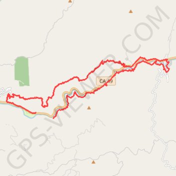
Name: North Yuba River MTB Loop trail, distance, elevation, map, profile, GPS track
End: CA 49, Goodyears Bar, Sierra County, California, United States (39.51383 -120.97626)
Coordinates: 39.51061 -120.99676 39.54314 -120.88427
Topography: Sierra County topographic map, elevation, terrain
Thank you for supporting this site ❤️
Make a donation
Make a donation
Gear up for your next adventure:
As an Amazon Associate, this site earns from qualifying purchases at no extra cost to you.