Make a donation
Gear up for your next adventure:
As an Amazon Associate, this site earns from qualifying purchases at no extra cost to you.
Norman Point
- Distance: 3.4 mi
- Elevation gain: 564 ft
- Maximum elevation: 226 ft
- Elevation loss: 574 ft
- Minimum elevation: 20 ft
- Moving time: 1 h 3 m
- Moving speed: 3.2 mph
- Maximum speed: 9.1 mph
- Total time: 1 h 26 m
- Global speed: 2.3 mph
Interactive trail map
Make a donation
Gear up for your next adventure:
As an Amazon Associate, this site earns from qualifying purchases at no extra cost to you.
Trail profile
- Distance: 3.4 mi
- Elevation gain: 564 ft
- Maximum elevation: 226 ft
- Elevation loss: 574 ft
- Minimum elevation: 20 ft
- Moving time: 1 h 3 m
- Moving speed: 3.2 mph
- Maximum speed: 9.1 mph
- Total time: 1 h 26 m
- Global speed: 2.3 mph
Make a donation
Gear up for your next adventure:
As an Amazon Associate, this site earns from qualifying purchases at no extra cost to you.
About this trail
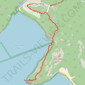
Name: Norman Point trail, distance, elevation, map, profile, GPS track
Coordinates: -39.05230 146.31742 -39.03012 146.32871
Make a donation
Gear up for your next adventure:
As an Amazon Associate, this site earns from qualifying purchases at no extra cost to you.
Other hiking, mountain biking, running and outdoor activity trails
Click on a trail to view its statistics, map and profile.
Wilsons Promontory Circuit
Australia > Victoria > Tidal River
Wilsons Promontory Marine National Park. #Hiking #Loop #WilsonsPromontory
Distance: 45.1 mi • Elevation gain: 10,627 ft • Maximum elevation: 1,768 ft
2023 Prom 100 km Run
Australia > Victoria > Tidal River
Distance: 63.0 mi • Elevation gain: 12,956 ft • Maximum elevation: 1,007 ft
Make a donation
Gear up for your next adventure:
As an Amazon Associate, this site earns from qualifying purchases at no extra cost to you.