Thank you for supporting this site ❤️
Make a donation
Make a donation
Gear up for your next adventure:
As an Amazon Associate, this site earns from qualifying purchases at no extra cost to you.
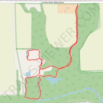
Old Miner's Loop Trail
- Distance: 1.8 mi
- Elevation gain: 36 ft
- Maximum elevation: 732 ft
- Elevation loss: 36 ft
- Minimum elevation: 712 ft
- Moving time: 46 m 36 s
- Moving speed: 2.3 mph
- Maximum speed: 3.5 mph
- Total time: 52 m
- Global speed: 2.1 mph
Interactive trail map
Thank you for supporting this site ❤️
Make a donation
Make a donation
Gear up for your next adventure:
As an Amazon Associate, this site earns from qualifying purchases at no extra cost to you.
Trail profile
- Distance: 1.8 mi
- Elevation gain: 36 ft
- Maximum elevation: 732 ft
- Elevation loss: 36 ft
- Minimum elevation: 712 ft
- Moving time: 46 m 36 s
- Moving speed: 2.3 mph
- Maximum speed: 3.5 mph
- Total time: 52 m
- Global speed: 2.1 mph
Thank you for supporting this site ❤️
Make a donation
Make a donation
Gear up for your next adventure:
As an Amazon Associate, this site earns from qualifying purchases at no extra cost to you.
About this trail
Name: Old Miner's Loop Trail trail, distance, elevation, map, profile, GPS track
Start: Old Miners' Trail, Champaign County, Illinois, United States (40.39880 -87.97568)
End: Old Miners' Trail, Champaign County, Illinois, United States (40.39895 -87.97570)
Coordinates: 40.39170 -87.98093 40.39895 -87.97566
Topography: Champaign County topographic map, elevation, terrain
Thank you for supporting this site ❤️
Make a donation
Make a donation
Gear up for your next adventure:
As an Amazon Associate, this site earns from qualifying purchases at no extra cost to you.