Thank you for supporting this site ❤️
Make a donation
Make a donation
Gear up for your next adventure:
As an Amazon Associate, this site earns from qualifying purchases at no extra cost to you.
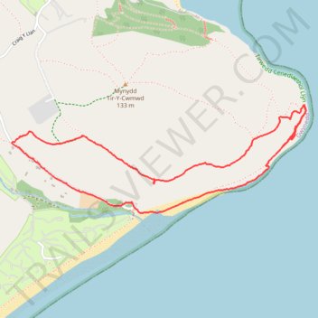
Ty'n Towyn walk to Quarry No 5 to climb
- Distance: 2.6 mi
- Elevation gain: 554 ft
- Maximum elevation: 322 ft
- Elevation loss: 561 ft
- Minimum elevation: 3 ft
- Moving time: 1 h 28 m
- Moving speed: 1.8 mph
- Maximum speed: 3.6 mph
- Total time: 4 h 15 m
- Global speed: 0.6 mph
Interactive trail map
Thank you for supporting this site ❤️
Make a donation
Make a donation
Gear up for your next adventure:
As an Amazon Associate, this site earns from qualifying purchases at no extra cost to you.
Trail profile
- Distance: 2.6 mi
- Elevation gain: 554 ft
- Maximum elevation: 322 ft
- Elevation loss: 561 ft
- Minimum elevation: 3 ft
- Moving time: 1 h 28 m
- Moving speed: 1.8 mph
- Maximum speed: 3.6 mph
- Total time: 4 h 15 m
- Global speed: 0.6 mph
Thank you for supporting this site ❤️
Make a donation
Make a donation
Gear up for your next adventure:
As an Amazon Associate, this site earns from qualifying purchases at no extra cost to you.
About this trail
Name: Ty'n Towyn walk to Quarry No 5 to climb trail, distance, elevation, map, profile, GPS track
Start: Llanbedrog, Gwynedd, Wales, LL53 7UW, United Kingdom (52.84496 -4.48242)
End: Llanbedrog, Gwynedd, Wales, LL53 7UW, United Kingdom (52.84493 -4.48242)
Coordinates: 52.84446 -4.49094 52.84914 -4.46999
Thank you for supporting this site ❤️
Make a donation
Make a donation
Gear up for your next adventure:
As an Amazon Associate, this site earns from qualifying purchases at no extra cost to you.