Thank you for supporting this site ❤️
Make a donation
Make a donation
Gear up for your next adventure:
As an Amazon Associate, this site earns from qualifying purchases at no extra cost to you.
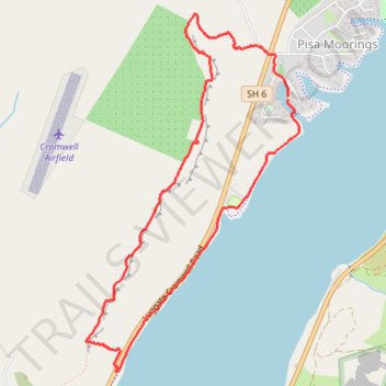
Pisa Moorings Loop Run
- Distance: 4.4 mi
- Elevation gain: 554 ft
- Maximum elevation: 1,043 ft
- Elevation loss: 558 ft
- Minimum elevation: 643 ft
- Moving time: 1 h 6 m
- Moving speed: 3.9 mph
- Maximum speed: 7.3 mph
- Total time: 1 h 13 m
- Global speed: 3.6 mph
Interactive trail map
Thank you for supporting this site ❤️
Make a donation
Make a donation
Gear up for your next adventure:
As an Amazon Associate, this site earns from qualifying purchases at no extra cost to you.
Trail profile
- Distance: 4.4 mi
- Elevation gain: 554 ft
- Maximum elevation: 1,043 ft
- Elevation loss: 558 ft
- Minimum elevation: 643 ft
- Moving time: 1 h 6 m
- Moving speed: 3.9 mph
- Maximum speed: 7.3 mph
- Total time: 1 h 13 m
- Global speed: 3.6 mph
Thank you for supporting this site ❤️
Make a donation
Make a donation
Gear up for your next adventure:
As an Amazon Associate, this site earns from qualifying purchases at no extra cost to you.
About this trail
Name: Pisa Moorings Loop Run trail, distance, elevation, map, profile, GPS track
Coordinates: -44.99833 169.21869 -44.97504 169.23835
Thank you for supporting this site ❤️
Make a donation
Make a donation
Gear up for your next adventure:
As an Amazon Associate, this site earns from qualifying purchases at no extra cost to you.
Other hiking, mountain biking, running and outdoor activity trails
Click on a trail to view its statistics, map and profile.