Make a donation
Gear up for your next adventure:
As an Amazon Associate, this site earns from qualifying purchases at no extra cost to you.
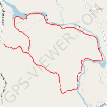
Bison Loop Trail in Wichita Mountains National Wildlife Refuge
The Bison Loop Trail is an inviting option for hikers of all ages, offering a leisurely path that meanders through picturesque landscapes. Along the route, visitors can expect to encounter majestic bison, serene lakes, and vibrant wildflowers that burst into color during springtime. The trail's relatively flat terrain allows for easy exploration, making it an excellent choice for families and those seeking a peaceful outdoor experience. #Hiking #Loop #Lake #Nature
- Distance: 6.3 mi
- Elevation gain: 449 ft
- Maximum elevation: 1,706 ft
- Elevation loss: 449 ft
- Minimum elevation: 1,470 ft
- Moving time: 2 h 53 m
- Moving speed: 2.2 mph
- Maximum speed: 3.8 mph
- Total time: 3 h 28 m
- Global speed: 1.8 mph
Interactive trail map
Make a donation
Gear up for your next adventure:
As an Amazon Associate, this site earns from qualifying purchases at no extra cost to you.
Trail profile
- Distance: 6.3 mi
- Elevation gain: 449 ft
- Maximum elevation: 1,706 ft
- Elevation loss: 449 ft
- Minimum elevation: 1,470 ft
- Moving time: 2 h 53 m
- Moving speed: 2.2 mph
- Maximum speed: 3.8 mph
- Total time: 3 h 28 m
- Global speed: 1.8 mph
Make a donation
Gear up for your next adventure:
As an Amazon Associate, this site earns from qualifying purchases at no extra cost to you.
About this trail
Name: Bison Loop Trail in Wichita Mountains National Wildlife Refuge trail, distance, elevation, map, profile, GPS track
Start: Longhorn Trail, Comanche County, Oklahoma, United States (34.71624 -98.70584)
End: Longhorn Trail, Comanche County, Oklahoma, United States (34.71619 -98.70587)
Coordinates: 34.70382 -98.70588 34.72388 -98.67565
Topography: Comanche County topographic map, elevation, terrain
Make a donation
Gear up for your next adventure:
As an Amazon Associate, this site earns from qualifying purchases at no extra cost to you.