Make a donation
Gear up for your next adventure:
As an Amazon Associate, this site earns from qualifying purchases at no extra cost to you.
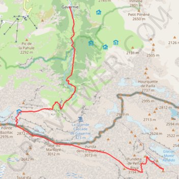
Mont Perdu - Gavernie
Interactive trail map
Make a donation
Gear up for your next adventure:
As an Amazon Associate, this site earns from qualifying purchases at no extra cost to you.
Trail profile
- Distance: 9.4 mi
- Elevation gain: 1,463 ft
- Maximum elevation: 10,932 ft
- Elevation loss: 7,884 ft
- Minimum elevation: 4,508 ft
Make a donation
Gear up for your next adventure:
As an Amazon Associate, this site earns from qualifying purchases at no extra cost to you.
About this trail
Name: Mont Perdu - Gavernie trail, distance, elevation, map, profile, GPS track
Start: Camino de Monte Perido, Bielsa, Sobrarbe, Huesca, Aragon, Spain (42.67578 0.03445)
Coordinates: 42.67507 -0.03489 42.73221 0.03454
Make a donation
Gear up for your next adventure:
As an Amazon Associate, this site earns from qualifying purchases at no extra cost to you.
Other hiking, mountain biking, running and outdoor activity trails
Click on a trail to view its statistics, map and profile.
GR 10 - Traversée des Pyrénées
France > Occitania > Pyrénées-Orientales > Banyuls-sur-Mer
Distance: 543.6 mi • Elevation gain: 187,008 ft • Maximum elevation: 8,527 ft
Day 4 Gavarnie from Hotellerie to Grande Cascade
France > Occitania > Hautes Pyrenees > Gavarnie-Gèdre > Gavarnie
Distance: 0.7 mi • Elevation gain: 709 ft • Maximum elevation: 5,863 ft
Day 4 Harder walking - Espugues path
France > Occitania > Hautes Pyrenees > Gavarnie-Gèdre > Gavarnie
Distance: 2.8 mi • Elevation gain: 1,161 ft • Maximum elevation: 5,938 ft
Day 4 Standard route at Gavarnie
France > Occitania > Hautes Pyrenees > Gavarnie-Gèdre > Gavarnie
Distance: 6.3 mi • Elevation gain: 1,624 ft • Maximum elevation: 5,600 ft
Make a donation
Gear up for your next adventure:
As an Amazon Associate, this site earns from qualifying purchases at no extra cost to you.
Southern section — European Divide Trail
France > Auvergne-Rhône-Alpes > Drôme > Valence
Distance: 1,506.1 mi • Elevation gain: 139,026 ft • Maximum elevation: 6,578 ft
1 LUCENA - MONTPELLIER
Distance: 1,842.0 mi • Elevation gain: 96,785 ft • Maximum elevation: 3,438 ft