Make a donation
Gear up for your next adventure:
As an Amazon Associate, this site earns from qualifying purchases at no extra cost to you.
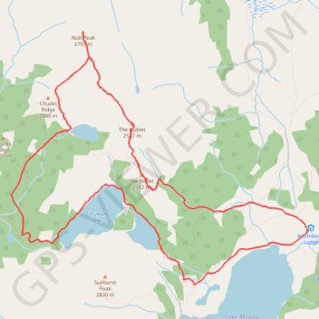
Assiniboine Lodge - The Nublet - Nub Peak - Elizabeth lake - Sunburst Valley - Cerulean Lake
Mount Assiniboine Provincial Park. #Hiking #Loop #Assiniboine
- Distance: 7.8 mi
- Elevation gain: 2,411 ft
- Maximum elevation: 8,983 ft
- Elevation loss: 2,418 ft
- Minimum elevation: 7,011 ft
Interactive trail map
Make a donation
Gear up for your next adventure:
As an Amazon Associate, this site earns from qualifying purchases at no extra cost to you.
Trail profile
- Distance: 7.8 mi
- Elevation gain: 2,411 ft
- Maximum elevation: 8,983 ft
- Elevation loss: 2,418 ft
- Minimum elevation: 7,011 ft
Make a donation
Gear up for your next adventure:
As an Amazon Associate, this site earns from qualifying purchases at no extra cost to you.
About this trail
Name: Assiniboine Lodge - The Nublet - Nub Peak - Elizabeth lake - Sunburst Valley - Cerulean Lake trail, distance, elevation, map, profile, GPS track
Coordinates: 50.90407 -115.66970 50.93046 -115.62058
Make a donation
Gear up for your next adventure:
As an Amazon Associate, this site earns from qualifying purchases at no extra cost to you.
Other hiking, mountain biking, running and outdoor activity trails
Click on a trail to view its statistics, map and profile.
Nub Peak via Sunburst Lake and The Nub
Canada > British Columbia > Regional District of East Kootenay > Area G (Forster Creek/Mount Assiniboine)
Distance: 2.9 mi • Elevation gain: 1,841 ft • Maximum elevation: 8,947 ft