Thank you for supporting this site ❤️
Make a donation
Make a donation
Gear up for your next adventure:
As an Amazon Associate, this site earns from qualifying purchases at no extra cost to you.
Baltimore spin
Interactive trail map
Thank you for supporting this site ❤️
Make a donation
Make a donation
Gear up for your next adventure:
As an Amazon Associate, this site earns from qualifying purchases at no extra cost to you.
Trail profile
- Distance: 58.9 mi
- Elevation gain: 4,629 ft
- Maximum elevation: 404 ft
- Elevation loss: 4,626 ft
- Minimum elevation: 0 ft
Thank you for supporting this site ❤️
Make a donation
Make a donation
Gear up for your next adventure:
As an Amazon Associate, this site earns from qualifying purchases at no extra cost to you.
About this trail
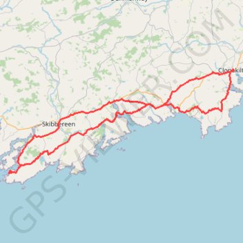
Name: Baltimore spin trail, distance, elevation, map, profile, GPS track
End: Clonakilty Urban ED, West Cork, County Cork, Munster, P85 XE95, Ireland (51.62278 -8.88483)
Coordinates: 51.48294 -9.37404 51.62325 -8.88348
Thank you for supporting this site ❤️
Make a donation
Make a donation
Gear up for your next adventure:
As an Amazon Associate, this site earns from qualifying purchases at no extra cost to you.