Make a donation
Gear up for your next adventure:
As an Amazon Associate, this site earns from qualifying purchases at no extra cost to you.
2026-06-22_10-22_Mon
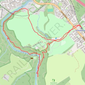
- Distance: 3.1 mi
- Elevation gain: 259 ft
- Maximum elevation: 276 ft
- Elevation loss: 259 ft
- Minimum elevation: 118 ft
- Moving time: 58 m 17 s
- Moving speed: 3.2 mph
- Maximum speed: 11.4 mph
- Total time: 58 m 17 s
- Global speed: 3.2 mph
Interactive trail map
Make a donation
Gear up for your next adventure:
As an Amazon Associate, this site earns from qualifying purchases at no extra cost to you.
Trail profile
- Distance: 3.1 mi
- Elevation gain: 259 ft
- Maximum elevation: 276 ft
- Elevation loss: 259 ft
- Minimum elevation: 118 ft
- Moving time: 58 m 17 s
- Moving speed: 3.2 mph
- Maximum speed: 11.4 mph
- Total time: 58 m 17 s
- Global speed: 3.2 mph
Make a donation
Gear up for your next adventure:
As an Amazon Associate, this site earns from qualifying purchases at no extra cost to you.
About this trail
Name: 2026-06-22_10-22_Mon trail, distance, elevation, map, profile, GPS track
Coordinates: 55.75761 -4.02590 55.76818 -4.00435
Make a donation
Gear up for your next adventure:
As an Amazon Associate, this site earns from qualifying purchases at no extra cost to you.
Other hiking, mountain biking, running and outdoor activity trails
Click on a trail to view its statistics, map and profile.
Tracked with OSMTracker for Android™
United Kingdom > Scotland > South Lanarkshire > Allanton
Distance: 3.1 mi • Elevation gain: 256 ft • Maximum elevation: 276 ft
2026-06-22_10-21_Mon
United Kingdom > Scotland > South Lanarkshire > Allanton
Distance: 3.1 mi • Elevation gain: 230 ft • Maximum elevation: 276 ft