Make a donation
Gear up for your next adventure:
As an Amazon Associate, this site earns from qualifying purchases at no extra cost to you.
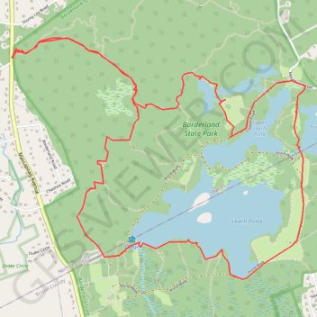
Borderland Park Loop
Loop hike in the Borderland State Park via Northwest Trail, Split Rock Trail, Granite Hills Trail, Granite Hills Lower Loop, Tisdale Road, Upper Leach Pond, Puds Pond, Pond Walk, Leach Pond, Pond Edge Trail, West Side Trail and The French Trail. #Hiking #Loop #Park #Nature #Lake #Forest
- Distance: 5.9 mi
- Elevation gain: 266 ft
- Maximum elevation: 318 ft
- Elevation loss: 269 ft
- Minimum elevation: 207 ft
- Moving time: 3 h 9 m
- Moving speed: 1.9 mph
- Maximum speed: 3.7 mph
- Total time: 3 h 30 m
- Global speed: 1.7 mph
Interactive trail map
Make a donation
Gear up for your next adventure:
As an Amazon Associate, this site earns from qualifying purchases at no extra cost to you.
Trail profile
- Distance: 5.9 mi
- Elevation gain: 266 ft
- Maximum elevation: 318 ft
- Elevation loss: 269 ft
- Minimum elevation: 207 ft
- Moving time: 3 h 9 m
- Moving speed: 1.9 mph
- Maximum speed: 3.7 mph
- Total time: 3 h 30 m
- Global speed: 1.7 mph
Make a donation
Gear up for your next adventure:
As an Amazon Associate, this site earns from qualifying purchases at no extra cost to you.
About this trail
Name: Borderland Park Loop trail, distance, elevation, map, profile, GPS track
Start: Northwest Trail, Sharon, Norfolk County, Massachusetts, 02067, United States (42.07560 -71.17240)
Coordinates: 42.06109 -71.17257 42.07668 -71.14706
Topography: Norfolk County topographic map, elevation, terrain
Make a donation
Gear up for your next adventure:
As an Amazon Associate, this site earns from qualifying purchases at no extra cost to you.
Other hiking, mountain biking, running and outdoor activity trails
Click on a trail to view its statistics, map and profile.
Cambridge - Providence Express
United States > Massachusetts > Middlesex County > Cambridge
Alewife -> Providence
Distance: 63.2 mi • Elevation gain: 3,153 ft • Maximum elevation: 351 ft
Dedham-Providence-Dedham
United States > Massachusetts > Norfolk County > Dedham
Distance: 126.0 mi • Elevation gain: 5,942 ft • Maximum elevation: 548 ft