Make a donation
Gear up for your next adventure:
As an Amazon Associate, this site earns from qualifying purchases at no extra cost to you.
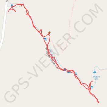
Mouse's Tank
Hike along Fire Canyon Wash to Mouse's Tank via Petroglyph Canyon Trail in the Valley of Fire State Park. #Hiking #Nature #Desert #Rock #Park
- Distance: 1.1 mi
- Elevation gain: 131 ft
- Maximum elevation: 2,110 ft
- Elevation loss: 131 ft
- Minimum elevation: 2,047 ft
- Moving time: 37 m 12 s
- Moving speed: 1.7 mph
- Maximum speed: 4.0 mph
- Total time: 1 h 5 m
- Global speed: 1.0 mph
Interactive trail map
Make a donation
Gear up for your next adventure:
As an Amazon Associate, this site earns from qualifying purchases at no extra cost to you.
Trail profile
- Distance: 1.1 mi
- Elevation gain: 131 ft
- Maximum elevation: 2,110 ft
- Elevation loss: 131 ft
- Minimum elevation: 2,047 ft
- Moving time: 37 m 12 s
- Moving speed: 1.7 mph
- Maximum speed: 4.0 mph
- Total time: 1 h 5 m
- Global speed: 1.0 mph
Make a donation
Gear up for your next adventure:
As an Amazon Associate, this site earns from qualifying purchases at no extra cost to you.
About this trail
Name: Mouse's Tank trail, distance, elevation, map, profile, GPS track
Start: Petroglyph Canyon Trail, Clark County, Nevada, United States (36.44076 -114.51666)
End: White Domes Road, Clark County, Nevada, United States (36.44079 -114.51664)
Coordinates: 36.43699 -114.51666 36.44109 -114.51196
Topography: Clark County topographic map, elevation, terrain
Make a donation
Gear up for your next adventure:
As an Amazon Associate, this site earns from qualifying purchases at no extra cost to you.