金馬倫北坑 金馬倫西坑
- Distance: 2.5 mi
- Elevation gain: 1,115 ft
- Maximum elevation: 1,309 ft
- Elevation loss: 1,138 ft
- Minimum elevation: 220 ft
- Moving time: 1 h 20 m
- Moving speed: 1.8 mph
- Maximum speed: 11.7 mph
- Total time: 2 h 52 m
- Global speed: 0.9 mph
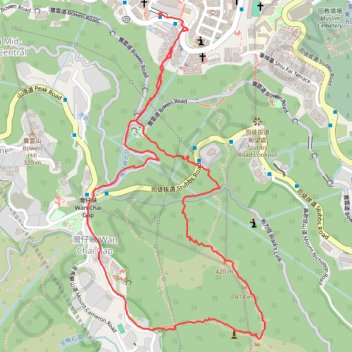
Interactive trail map
Trail profile
- Distance: 2.5 mi
- Elevation gain: 1,115 ft
- Maximum elevation: 1,309 ft
- Elevation loss: 1,138 ft
- Minimum elevation: 220 ft
- Moving time: 1 h 20 m
- Moving speed: 1.8 mph
- Maximum speed: 11.7 mph
- Total time: 2 h 52 m
- Global speed: 0.9 mph
About this trail
Name: 金馬倫北坑 金馬倫西坑 trail, distance, elevation, map, profile, GPS track
Coordinates: 22.26320 114.16985 22.27384 114.17613
Other hiking, mountain biking, running and outdoor activity trails
Click on a trail to view its statistics, map and profile.
Wilson Trail Full Route
China > Hong Kong > Hong Kong Island
Distance: 50.5 mi • Elevation gain: 14,534 ft • Maximum elevation: 2,011 ft
Hong Kong island ride
China > Hong Kong > Hong Kong Island
#Bike
Distance: 38.4 mi • Elevation gain: 7,060 ft • Maximum elevation: 1,657 ft
Trail Planner Map
China > Hong Kong > Hong Kong Island
Distance: 12.6 mi • Elevation gain: 3,776 ft • Maximum elevation: 1,388 ft
荷兰径
China > Hong Kong > Hong Kong Island
Outdoor walk
Distance: 5.3 mi • Elevation gain: 2,356 ft • Maximum elevation: 1,093 ft
金鴨中段 灣仔峽南坑右源 灣仔峽北坑
China > Hong Kong > Hong Kong Island
Hong Kong Island Hike
Distance: 2.3 mi • Elevation gain: 653 ft • Maximum elevation: 837 ft