Thank you for supporting this site ❤️
Make a donation
Make a donation
Gear up for your next adventure:
As an Amazon Associate, this site earns from qualifying purchases at no extra cost to you.
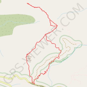
Afternoon hike at Winston Peak
- Distance: 5.0 mi
- Elevation gain: 1,552 ft
- Maximum elevation: 7,490 ft
- Elevation loss: 1,555 ft
- Minimum elevation: 6,591 ft
- Moving time: 2 h 44 m
- Moving speed: 1.8 mph
- Maximum speed: 3.7 mph
- Total time: 4 h 47 m
- Global speed: 1.0 mph
Interactive trail map
Thank you for supporting this site ❤️
Make a donation
Make a donation
Gear up for your next adventure:
As an Amazon Associate, this site earns from qualifying purchases at no extra cost to you.
Trail profile
- Distance: 5.0 mi
- Elevation gain: 1,552 ft
- Maximum elevation: 7,490 ft
- Elevation loss: 1,555 ft
- Minimum elevation: 6,591 ft
- Moving time: 2 h 44 m
- Moving speed: 1.8 mph
- Maximum speed: 3.7 mph
- Total time: 4 h 47 m
- Global speed: 1.0 mph
Thank you for supporting this site ❤️
Make a donation
Make a donation
Gear up for your next adventure:
As an Amazon Associate, this site earns from qualifying purchases at no extra cost to you.
About this trail
Name: Afternoon hike at Winston Peak trail, distance, elevation, map, profile, GPS track
Coordinates: 34.35120 -117.93625 34.37127 -117.92561
Topography: Los Angeles County topographic map, elevation, terrain
Thank you for supporting this site ❤️
Make a donation
Make a donation
Gear up for your next adventure:
As an Amazon Associate, this site earns from qualifying purchases at no extra cost to you.