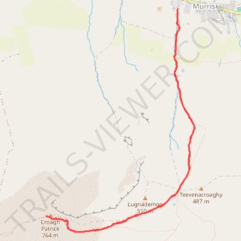
Croagh Patrick Hike
- Distance: 4.5 mi
- Elevation gain: 2,379 ft
- Maximum elevation: 2,484 ft
- Elevation loss: 2,415 ft
- Minimum elevation: 66 ft
- Moving time: 2 h 7 m
- Moving speed: 2.1 mph
- Maximum speed: 6.4 mph
- Total time: 2 h 14 m
- Global speed: 2.0 mph
Interactive trail map
Trail profile
- Distance: 4.5 mi
- Elevation gain: 2,379 ft
- Maximum elevation: 2,484 ft
- Elevation loss: 2,415 ft
- Minimum elevation: 66 ft
- Moving time: 2 h 7 m
- Moving speed: 2.1 mph
- Maximum speed: 6.4 mph
- Total time: 2 h 14 m
- Global speed: 2.0 mph
About this trail
Name: Croagh Patrick Hike trail, distance, elevation, map, profile, GPS track
Coordinates: 53.75855 -9.65977 53.77874 -9.63706
Other hiking, mountain biking, running and outdoor activity trails
Click on a trail to view its statistics, map and profile.
Croagh Patrick
Distance: 4.8 mi • Elevation gain: 2,428 ft • Maximum elevation: 2,484 ft
Connemara - Day 1
Ireland > County Galway > Leenaun
#Bike
Distance: 38.6 mi • Elevation gain: 2,136 ft • Maximum elevation: 249 ft
New path on Croagh Patrick
County Mayo Walking
Distance: 2.3 mi • Elevation gain: 2,425 ft • Maximum elevation: 2,480 ft