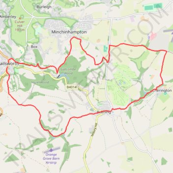
Nailsworth to Cherington loop
- Distance: 11.3 mi
- Elevation gain: 1,322 ft
- Maximum elevation: 627 ft
- Elevation loss: 1,302 ft
- Minimum elevation: 200 ft
- Moving time: 3 h 23 m
- Moving speed: 3.3 mph
- Maximum speed: 7.5 mph
- Total time: 4 h 4 m
- Global speed: 2.8 mph
Interactive trail map
Trail profile
- Distance: 11.3 mi
- Elevation gain: 1,322 ft
- Maximum elevation: 627 ft
- Elevation loss: 1,302 ft
- Minimum elevation: 200 ft
- Moving time: 3 h 23 m
- Moving speed: 3.3 mph
- Maximum speed: 7.5 mph
- Total time: 4 h 4 m
- Global speed: 2.8 mph
About this trail
Name: Nailsworth to Cherington loop trail, distance, elevation, map, profile, GPS track
Coordinates: 51.67214 -2.21913 51.70371 -2.13730
Other hiking, mountain biking, running and outdoor activity trails
Click on a trail to view its statistics, map and profile.
Five Valleys Loop Walk
United Kingdom > England > Gloucestershire > Stroud > Randwick
Distance: 21.3 mi • Elevation gain: 2,976 ft • Maximum elevation: 830 ft
Toadsmoor Valley
United Kingdom > England > Gloucestershire > Nailsworth > Box
Distance: 19.5 mi • Elevation gain: 2,753 ft • Maximum elevation: 774 ft
Loop walk from Nailsworth to Kingscote
United Kingdom > England > Gloucestershire > Nailsworth > Box
Distance: 7.6 mi • Elevation gain: 968 ft • Maximum elevation: 699 ft
Nailsworth - Brimscombe
United Kingdom > England > Gloucestershire > Nailsworth > Box
Distance: 6.4 mi • Elevation gain: 1,056 ft • Maximum elevation: 673 ft
Nailsworth to Kingscote Loop
United Kingdom > England > Gloucestershire > Nailsworth > Inchbrook
Distance: 7.2 mi • Elevation gain: 896 ft • Maximum elevation: 699 ft
Woodchester Stroud Walking
United Kingdom > England > Gloucestershire > Nailsworth > Box
Distance: 14.1 mi • Elevation gain: 1,611 ft • Maximum elevation: 692 ft
Minchinhampton loop
United Kingdom > England > Gloucestershire > Nailsworth > Box
Distance: 13.1 mi • Elevation gain: 1,358 ft • Maximum elevation: 673 ft
NW to Stroud
United Kingdom > England > Gloucestershire > Nailsworth > Inchbrook
Stroud Walking
Distance: 11.9 mi • Elevation gain: 1,480 ft • Maximum elevation: 656 ft
Gatcombe Park
United Kingdom > England > Gloucestershire > Nailsworth > Box
Distance: 13.4 mi • Elevation gain: 1,483 ft • Maximum elevation: 636 ft
Avening loop
United Kingdom > England > Gloucestershire > Nailsworth > Box
Distance: 11.0 mi • Elevation gain: 1,079 ft • Maximum elevation: 610 ft
Dean2023-311
United Kingdom > England > Oxfordshire > Oxford
Distance: 192.8 mi • Elevation gain: 11,043 ft • Maximum elevation: 951 ft
Kingscote Glos
United Kingdom > England > Gloucestershire > Nailsworth > Box
Distance: 11.3 mi • Elevation gain: 1,171 ft • Maximum elevation: 735 ft
Stroud direct
United Kingdom > England > Gloucestershire > Nailsworth > Box
Distance: 10.0 mi • Elevation gain: 988 ft • Maximum elevation: 673 ft
Five Valleys
United Kingdom > England > Gloucestershire > Stonehouse > Leonard Stanley
Distance: 23.7 mi • Elevation gain: 2,894 ft • Maximum elevation: 830 ft
Avening
United Kingdom > England > Gloucestershire > Nailsworth > Box
Distance: 6.1 mi • Elevation gain: 846 ft • Maximum elevation: 633 ft