Make a donation
Gear up for your next adventure:
As an Amazon Associate, this site earns from qualifying purchases at no extra cost to you.
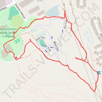
Area surrounding Bike Park of Santa Clarita
- Distance: 1.7 mi
- Elevation gain: 282 ft
- Maximum elevation: 1,637 ft
- Elevation loss: 282 ft
- Minimum elevation: 1,375 ft
- Moving time: 48 m 25 s
- Moving speed: 2.1 mph
- Maximum speed: 6.8 mph
- Total time: 58 m 39 s
- Global speed: 1.8 mph
Interactive trail map
Make a donation
Gear up for your next adventure:
As an Amazon Associate, this site earns from qualifying purchases at no extra cost to you.
Trail profile
- Distance: 1.7 mi
- Elevation gain: 282 ft
- Maximum elevation: 1,637 ft
- Elevation loss: 282 ft
- Minimum elevation: 1,375 ft
- Moving time: 48 m 25 s
- Moving speed: 2.1 mph
- Maximum speed: 6.8 mph
- Total time: 58 m 39 s
- Global speed: 1.8 mph
Make a donation
Gear up for your next adventure:
As an Amazon Associate, this site earns from qualifying purchases at no extra cost to you.
About this trail
Name: Area surrounding Bike Park of Santa Clarita trail, distance, elevation, map, profile, GPS track
Coordinates: 34.40735 -118.49972 34.41306 -118.49170
Topography: Santa Clarita topographic map, elevation, terrain
Make a donation
Gear up for your next adventure:
As an Amazon Associate, this site earns from qualifying purchases at no extra cost to you.
Other hiking, mountain biking, running and outdoor activity trails
Click on a trail to view its statistics, map and profile.
Santa Clarita Sports Complex Loop Trail
United States > California > Los Angeles County > Santa Clarita
Distance: 1.0 mi • Elevation gain: 154 ft • Maximum elevation: 1,562 ft