Make a donation
Gear up for your next adventure:
As an Amazon Associate, this site earns from qualifying purchases at no extra cost to you.
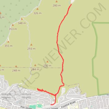
Hall Canyon
From Hall Canyon Road, the route enters Ventura Hills Nature Preserve and follows the quiet canyon corridor between open foothill slopes.
It continues along dry washes and coastal scrub typical of Ventura’s protected hillside landscape.
The walk reaches the split between West Fork Hall Canyon and East Fork Hall Canyon, then returns through the same natural corridor.
#Hiking #Canyon #Nature
- Distance: 4.7 mi
- Elevation gain: 633 ft
- Maximum elevation: 430 ft
- Elevation loss: 597 ft
- Minimum elevation: 184 ft
- Moving time: 1 h 41 m
- Moving speed: 2.8 mph
- Maximum speed: 5.8 mph
- Total time: 1 h 45 m
- Global speed: 2.7 mph
Interactive trail map
Make a donation
Gear up for your next adventure:
As an Amazon Associate, this site earns from qualifying purchases at no extra cost to you.
Trail profile
- Distance: 4.7 mi
- Elevation gain: 633 ft
- Maximum elevation: 430 ft
- Elevation loss: 597 ft
- Minimum elevation: 184 ft
- Moving time: 1 h 41 m
- Moving speed: 2.8 mph
- Maximum speed: 5.8 mph
- Total time: 1 h 45 m
- Global speed: 2.7 mph
Make a donation
Gear up for your next adventure:
As an Amazon Associate, this site earns from qualifying purchases at no extra cost to you.
About this trail
Name: Hall Canyon trail, distance, elevation, map, profile, GPS track
Coordinates: 34.28019 -119.26455 34.30594 -119.25411
Topography: San Buenaventura (Ventura) topographic map, elevation, terrain
Make a donation
Gear up for your next adventure:
As an Amazon Associate, this site earns from qualifying purchases at no extra cost to you.
Other hiking, mountain biking, running and outdoor activity trails
Click on a trail to view its statistics, map and profile.
Ventura Hills Nature Preserve Trails 101 and 102 Loop
United States > California > Ventura County > Ventura
Distance: 4.9 mi • Elevation gain: 1,240 ft • Maximum elevation: 853 ft
Ride in Ventura Hills preserve
United States > California > Ventura County > San Buenaventura (Ventura)
Distance: 10.4 mi • Elevation gain: 2,011 ft • Maximum elevation: 1,161 ft
101 Trail and Fire Road
United States > California > Ventura County > San Buenaventura (Ventura)
Distance: 5.2 mi • Elevation gain: 1,329 ft • Maximum elevation: 1,129 ft