Bearfence Mountain Trail in Shenandoah National Park
The Bearfence Mountain Trail is a short but exciting hike, especially known for its thrilling rock scramble. The route is moderately challenging, but the adrenaline-pumping scramble rewards you with a breathtaking 360-degree view over the Shenandoah Valley and the Blue Ridge Mountains. It’s a perfect mix of adventure and scenic beauty, but be cautious if you're not a fan of heights or if the rocks are wet, as conditions can make the scramble treacherous. #Hiking #Mountain #Forest #Nature
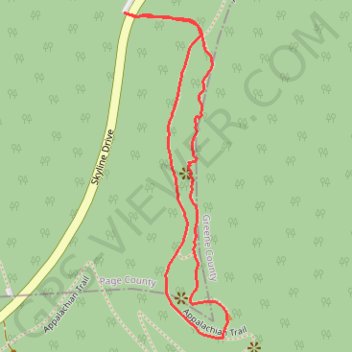
- Distance: 1.1 mi
- Elevation gain: 236 ft
- Maximum elevation: 3,530 ft
- Elevation loss: 236 ft
- Minimum elevation: 3,294 ft
- Moving time: 35 m 24 s
- Moving speed: 1.9 mph
- Maximum speed: 3.8 mph
- Total time: 51 m 38 s
- Global speed: 1.3 mph
Interactive trail map
Trail profile
- Distance: 1.1 mi
- Elevation gain: 236 ft
- Maximum elevation: 3,530 ft
- Elevation loss: 236 ft
- Minimum elevation: 3,294 ft
- Moving time: 35 m 24 s
- Moving speed: 1.9 mph
- Maximum speed: 3.8 mph
- Total time: 51 m 38 s
- Global speed: 1.3 mph
About this trail
Name: Bearfence Mountain Trail in Shenandoah National Park trail, distance, elevation, map, profile, GPS track
Start: Bearfence Parking Area, Skyline Drive, Page County, Virginia, United States (38.45240 -78.46706)
End: Bearfence Parking Area, Skyline Drive, Page County, Virginia, United States (38.45240 -78.46704)
Coordinates: 38.44670 -78.46706 38.45240 -78.46474
Topography: Page County topographic map, elevation, terrain
Other hiking, mountain biking, running and outdoor activity trails
Click on a trail to view its statistics, map and profile.
Bearfence Mountain Loop via Bearfence Mountain Trail and Appalachian
United States > Virginia > Page County
The Bearfence Mountain Loop offers a captivating and varied hike in Shenandoah National Park, known for its combination of rock scrambling and spectacular views. As you ascend, you'll enjoy panoramic vistas of the Shenandoah Valley and the Virginia Piedmont, including expansive views of the surrounding Blue…
Distance: 1.1 mi • Elevation gain: 236 ft • Maximum elevation: 3,530 ft